


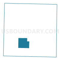
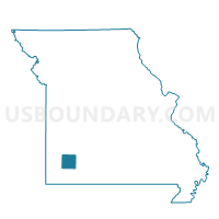
Freistatt Voting District, Lawrence County, Missouri
About
Outline

Summary
| Unique Area Identifier | 608948 |
| Name | Freistatt Voting District |
| County | Lawrence County |
| State | Missouri |
| Area (square miles) | 21.08 |
| Land Area (square miles) | 21.07 |
| Water Area (square miles) | 0.01 |
| % of Land Area | 99.93 |
| % of Water Area | 0.07 |
| Latitude of the Internal Point | 37.01987520 |
| Longtitude of the Internal Point | -93.88844690 |
Maps

Graphs
Select a template below for downloading or customizing gragh for Freistatt Voting District, Lawrence County, Missouri


Neighbors
Neighoring Voting District (by Name) Neighboring Voting District on the Map
- Forest Park Voting District, Lawrence County, MO
- Hoberg Voting District, Lawrence County, MO
- Mt. Pleasant Voting District, Lawrence County, MO
- Pierce City Voting District, Lawrence County, MO
- Spring River Voting District, Lawrence County, MO
Top 10 Neighboring County Subdivision (by Population) Neighboring County Subdivision on the Map
- Pierce township, Lawrence County, MO (6,586)
- Spring River township, Lawrence County, MO (2,199)
- Mount Pleasant township, Lawrence County, MO (922)
- Hoberg township, Lawrence County, MO (706)
- Freistatt township, Lawrence County, MO (549)
Top 10 Neighboring Place (by Population) Neighboring Place on the Map
Top 10 Neighboring Unified School District (by Population) Neighboring Unified School District on the Map
- Monett R-I School District, MO (12,231)
- Mount Vernon R-V School District, MO (9,214)
- Pierce City R-VI School District, MO (4,344)
- Verona R-VII School District, MO (2,395)